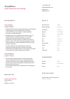
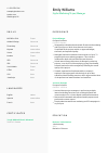
Geospatial Analyst CV Example
Plotting coordinates, but your CV feels directionless? Navigate this Geospatial Analyst CV example, charted with Wozber free CV builder. Unearth how to blend your spatial skills with job coordinates, mapping out a career that reaches the peaks and valleys of success!
How to write a Geospatial Analyst CV?
Welcome to the world of Geospatial Analysis, where each day is a journey through data landscapes! If you're aiming to embark on a new adventure as a Geospatial Analyst, your CV isn't just a document—it's your passport. In today's competitive job market, standing out is crucial. That's where the magic of Wozber comes in!
With our free CV builder, ATS-friendly CV templates, and an ATS CV scanner tool, we'll guide you to create a CV that not only matches the job description like a glove but also navigates through the realm of Applicant Tracking Systems (ATS) with ease. Let the journey to your dream job begin!
Personal Details
First impressions count, especially in the world of CVs. Your personal details section is akin to a compass—it guides potential employers to you. Let's ensure your compass points true north, guiding you straight to that Geospatial Analyst position you're eyeing.
1. Identify Yourself Clearly
Your name is your banner, flying high above the rest of the information. Make sure it's clearly visible, using a readable font that stands out. Remember, you're not just a name; you're the next Geospatial Analyst wizard they're looking for.
2. Speak Their Language
Below your name, clearly state your professional title, which in this case is 'Geospatial Analyst'. This immediately tells the hiring manager, "Yes, I belong in this role". Mirroring the job title from the job description also helps with ATS optimisation.
3. Ensure Accessibility
Your contact information—phone number and email address—should be error-free and professional. A typo can misdirect your journey before it even begins, and an unprofessional email might make them question your seriousness about the role.
4. Pinpoint Your Location
Being based in the Washington, D.C. metropolitan area is a key requirement. Explicitly stating your location in this section aligns with one of the essential criteria and reassures the employer of your immediate availability.
5. Digital Presence Matters
If applicable, include your LinkedIn profile or a personal website that showcases your professional portfolio or projects. This can act as a treasure map, leading potential employers to discover more about your capabilities and achievements.
Takeaway
With your personal details neatly charted, you're ready to guide employers to your doorstep. Each detail is a coordinate leading them closer to you. Ensure accuracy and relevance, and you'll set the stage for a powerful first impression.


Experience
Your experience section is where your professional journey comes to life. It's a detailed map of where you've been and what you've accomplished. For a Geospatial Analyst role, weaving the story of your contributions and achievements with precision is key.
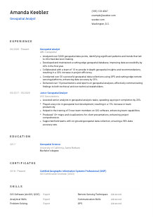
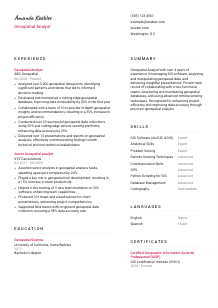
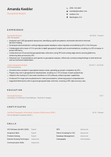
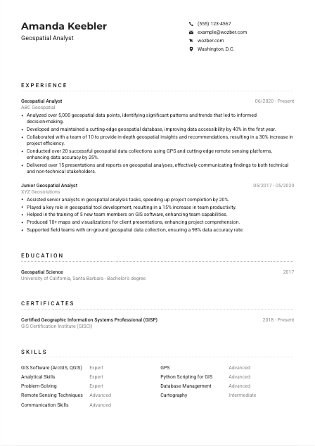
- Analyzed over 5,000 geospatial data points, identifying significant patterns and trends that led to informed decision‑making.
- Developed and maintained a cutting‑edge geospatial database, improving data accessibility by 40% in the first year.
- Collaborated with a team of 10 to provide in‑depth geospatial insights and recommendations, resulting in a 30% increase in project efficiency.
- Conducted over 20 successful geospatial data collections using GPS and cutting‑edge remote sensing platforms, enhancing data accuracy by 25%.
- Delivered over 15 presentations and reports on geospatial analyses, effectively communicating findings to both technical and non‑technical stakeholders.
- Assisted senior analysts in geospatial analysis tasks, speeding up project completion by 20%.
- Played a key role in geospatial tool development, resulting in a 15% increase in team productivity.
- Helped in the training of 5 new team members on GIS software, enhancing team capabilities.
- Produced 10+ maps and visualizations for client presentations, enhancing project comprehension.
- Supported field teams with on‑ground geospatial data collection, ensuring a 98% data accuracy rate.
1. Dissecting the Requirements
Begin by dissect the job description, focusing on keywords and essential skills. For instance, if it mentions 'analyzing geospatial data', reflect on moments you've triumphed in this task and prepare to showcase them.
2. Plot Your Journey
Present your experience in a clear, chronological order, starting with the most recent. Each position you've held should act as a waypoint--detailing your title, company, date, and encapsulating your geospatial adventures there.
3. Highlight Achievements
Craft statements that don't just show you've walked the walk but where you've left footprints. Quantify your achievements where possible: 'Analyzed over 5,000 geospatial data points, identifying significant patterns...' helps the hiring manager gauge the scale of your capabilities.
4. Quantify Your Impact
Numbers add scale and tangibility. Whenever possible, quantify your contributions. For example, 'enhancing project efficiency by 30%' or 'improving data accuracy by 25%' conveys your positive impact in a measureable way.
5. Relevance is King
Filter your experiences through the lens of the Geospatial Analyst role. Align them with the job requirements and the skills you've pinpointed. This won't just pass the ATS scan but will capture the hiring manager's attention too.
Takeaway
You've plotted a path that showcases your expertise and achievements. This section is your opportunity to shine, demonstrating not only that you're qualified but an invaluable asset. Keep it tailored, quantified, and relevant, and you'll be on your way to that next big opportunity.
Education
The education section of your CV might seem like a straightforward layover on your journey, but it holds key insights into your foundational knowledge. Let's ensure it underscores your qualification for the Geospatial Analyst position.
1. Align with the Job's Ask
Highlight the degree the job description calls for--'Bachelor's degree in Geography, Geospatial Science, GIS, or a related field.' This directly addresses one of the core requirements, aligning your education with the job's expectations.
2. Keep It Sleek and Straightforward
Listing your degree, the institution's name, and your graduation year keeps this section clean and digestible. Remember, the goal here is not to overwhelm but to affirm your qualifications.
3. Echo the Job's Language
If the job description emphasizes a specific area of expertise within your degree, make sure to highlight that. Adjust the phrasing of your degree title if needed to mirror the job description, enhancing the CV's ATS optimisation.
4. Coursework and Projects Matter
Especially if you're early in your career, related coursework or projects can serve as evidence of your skills and dedication. If you've undertaken specific studies or projects in geospatial analysis, now's the time to spotlight them.
5. Remember, Every Detail Counts
Additional honors, activities, or relevant coursework underscores your commitment and expertise. While senior roles might focus less on academic accolades, they still paint a picture of a driven and dedicated professional.
Takeaway
Your education section isn't just a list; it's proof of your preparedness and fit for the Geospatial Analyst role. By tailoring this section to the job's requirements, you're reinforcing your CV's relevance and direction. Keep it concise, relevant, and reflective of your journey.
Certificates
In the ocean of geospatial analysis, certificates are your navigational stars. They demonstrate your dedication to continuous learning and your prowess in specific areas. Let's ensure your certificates guide you closer to your dream job.
1. Identify Relevant Stars
Select certificates that shine brightly towards your target. For a Geospatial Analyst, 'Certified Geographic Information Systems Professional (GISP)' is a beacon, directly aligned with the job's core requirements and your professional development.
2. Showcase Your Constellation
While your CV might not be the night sky, choosing the brightest stars to display is key. Highlight certificates that directly relate to geospatial analysis, offering clarity and relevance to the role you desire.
3. Dates Illuminate Paths
If your certificate has a validity period or it's a recent conquest, include the date. This shows you're up-to-date with the latest trends and technologies, an essential trait in the ever-evolving world of geospatial analysis.
4. Never Stop Scanning the Horizon
The realm of geospatial analysis is constantly changing. Regularly updating your certificates and seeking new knowledge not only enhances your expertise but signals to employers your commitment to staying ahead in the field.
Takeaway
Properly presented, your certificates illuminate your dedication to professional growth and mastery in geospatial analysis. Keep this section polished and relevant, and let it serve as evidence of your relentless pursuit of knowledge. It's one more step towards standing out in a sea of candidates.
Skills
Skills are the tools you wield on your quest as a Geospatial Analyst. Your CV's skill section is where you showcase your professional arsenal. Let's ensure it's well-stocked with the most relevant and impactful tools for the job.
1. Decipher the Job's Code
Kick off by breaking down the job description for explicit and implicit skill requirements. Skills like 'GIS Software (ArcGIS, QGIS)' and 'Remote Sensing Techniques' aren't just keywords; they're the bread and butter of your role.
2. Sharpen Your Weapons
Focus on listing skills that align directly with the job requirements. Blend hard skills, like 'Python Scripting for GIS', with soft skills such as 'Analytical Skills' and 'Communication Skills' to present a well-rounded arsenal.
3. Keep Your Toolkit Organized
Resist the urge to list every skill you possess. Prioritize those most relevant and impactful for a Geospatial Analyst position. This not only passes the ATS scan but also makes your CV more digestible for the hiring manager.
Takeaway
Your skills section now showcases a carefully curated arsenal, directly aligned with the Geospatial Analyst role. By emphasizing the skills that resonate most with the job's requirements, you're not just fitting in—you're standing out. Keep these tools sharp and ready for action.
Languages
In the realm of geospatial analysis, communication is key. The ability to articulate findings, collaborate across borders, and navigate multilingual datasets can set you apart. Let's ensure your language skills are displayed proudly, adding another dimension to your candidacy.
1. Read the Map
Firstly, scrutinize the job description for any language requirements or preferences. The demand for 'Ability to operate in an English-speaking work environment' indicates that fluency in English is non-negotiable.
2. Prioritize Key Languages
List English at the top, denoting your proficiency level clearly. This directly meets the job's primary language requirement, ensuring you're not lost in translation right from the start.
3. Unveil Your Linguistic Range
While the job description may not specify additional languages, showcasing your multilingual capabilities can be a significant asset, especially in a field that values diverse cultural and geographical insights.
4. Honesty is Your Compass
Be truthful about your proficiency levels. Whether you're 'Fluent' or at an 'Intermediate' level, clear communication about your abilities ensures expectations are aligned, and there are no surprises down the line.
5. Understand the Terrain
For roles that might involve international collaborations or datasets, highlighting your linguistic ability could be a strong advantage. It's not just about speaking different languages, but understanding diverse perspectives and contexts.
Takeaway
By carefully mapping out your linguistic abilities, you show not only your communication prowess but also your potential to navigate the global landscape of geospatial analysis. Each language you speak is a passport to new opportunities, making your skill set even more invaluable.
Summary
The summary section of your CV is your initial handshake with potential employers. It's your chance to grab attention, setting the tone for the narrative of your professional journey. Let's craft a summary that captures the essence of your expertise as a Geospatial Analyst.
1. Embrace the Role
Start by internalizing the role you're applying for. As a Geospatial Analyst, your summary should resonate with skills in 'GIS software', 'analyzing and manipulating geospatial data', and 'delivering insightful presentations'. This initial framing is your beacon.
2. Begin Your Story
Open with an overarching statement of your professional self. 'Geospatial Analyst with over 4 years of experience...' immediately sets the stage for your narrative, teasing the depth of your journey and expertise.
3. Showcase Your Compass
Dive into a few of your most notable skills and achievements. By honing in on aspects like 'leveraging GIS software' and 'enhancing project efficiency', you're inviting the hiring manager on a guided tour of your professional landscape.
4. Keep It Crisp and Clear
A summary has to be just that—summary. Aim for a concise yet compelling narrative that ignites interest and paves the way for the detailed journey outlined in your CV. Think of it as your professional trailer, offering enticing glimpses of your story.
Takeaway
Your summary now serves as a powerful launchpad for your CV. It not only introduces you as a prime candidate for the Geospatial Analyst role but also sets the tone for the detailed narrative that follows. You've charted a course that piques interest; now let the rest of your CV bring it home.
Launching Your Geospatial Analyst Journey
Congratulations! You've meticulously crafted a CV that's not just tailored to the Geospatial Analyst position but is also primed for navigating through ATS. With each section fine-tuned and your skills and achievements shining brightly, your CV is now a beacon in the competitive job market. Remember, your CV is your story.
With Wozber's free CV builder, ATS-friendly CV templates, and ATS CV scanner, you're equipped to tell it in the most compelling way. The world is your oyster—go forth and chart your course to success!

- Bachelor's degree in Geography, Geospatial Science, GIS, or a related field.
- Minimum of 3 years of professional experience in geospatial data analysis and manipulation.
- Proficiency with GIS software such as ArcGIS, QGIS, or equivalent platforms.
- Solid understanding of remote sensing techniques and satellite imagery analysis.
- Strong analytical, problem-solving, and communication skills.
- Ability to operate in an English-speaking work environment.
- Must be located in Washington, D.C. metropolitan area.
- Analyze geospatial data to identify patterns, trends, and anomalies.
- Develop and maintain geospatial databases, tools, and applications to support organizational needs.
- Collaborate with cross-functional teams to provide in-depth geospatial insights and recommendations.
- Conduct geospatial data collection using various technologies, including GPS and remote sensing platforms.
- Deliver presentations and reports on geospatial analysis findings to both technical and non-technical stakeholders.

