Use Wozber and land your dream job
Create Resume
No registration required
Plotting coordinates, but your resume feels directionless? Navigate this Geospatial Analyst resume example, created with Wozber free resume builder. Learn how to blend your spatial skills with job coordinates, mapping out a career that reaches the peaks and valleys of success!
Geospatial analysis work gets judged by how well you turn raw spatial data into decisions people can use. Hiring teams want to see more than software familiarity. They look for analysts who can interpret patterns, manage reliable datasets, work with imagery or GPS inputs, and explain findings clearly enough for planners, project teams, or non-technical stakeholders to act on them.
The first resume pass often hinges on whether your geospatial experience is described in the same language as the role itself. Wozber's free resume builder helps you shape that language into an ATS-compliant resume, so terms like geospatial data analysis, GIS platforms, remote sensing, database maintenance, and stakeholder reporting are easy to find and easy to trust. That makes your resume faster to read as proof that you can handle real analysis work, not just mapping tasks.
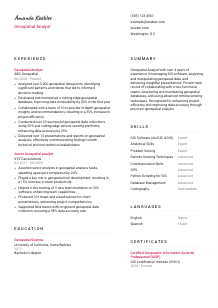
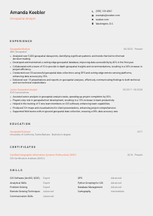
For a Geospatial Analyst, the header should do one job well: confirm who you are, how to reach you, and whether you meet any immediate screening requirements. Keep it clean and practical so the reader can move quickly to your GIS, database, and analysis experience.
Use your full name as the clearest element in the header. Keep the formatting simple and readable. Geospatial roles often attract candidates with technical portfolios, certifications, and software-heavy resumes, so your name should anchor the page without competing with extra design elements.
Place your target title directly below your name. If you are applying for a Geospatial Analyst opening, use "Geospatial Analyst" unless your background is substantially different and needs a more precise variation. Matching the title helps ATS parsing and tells the reader immediately that your experience should be evaluated against geospatial analysis, not a broader GIS technician or data support track.
List a working phone number and a professional email address, then verify both. This sounds basic, but it matters. If you are presenting yourself as someone who handles data quality, database upkeep, and analytical reporting, avoid small errors in the one section that should be flawless.
If the posting names a location requirement, include your city and state. Here, being in the Washington, D.C. metropolitan area is part of the screen, so showing "Washington, D.C." in the header addresses that requirement immediately. For other geospatial roles, only include location when it affects eligibility, field access, security, or onsite collaboration.
If you have a LinkedIn profile, portfolio, or personal site with map samples, dashboards, spatial data projects, or published analysis, include it. This is especially useful in geospatial hiring because a well-chosen link can show cartography quality, GIS workflow depth, or Python and database work that a one-page resume can only summarize.
Your personal details should answer the practical questions right away: who you are, whether you match the target role, how to contact you, and whether you meet any location requirement. Once that is clear, the rest of the resume can focus on your analytical range.


This section carries the most weight for a Geospatial Analyst. Employers want to see how you worked with spatial data, what tools or collection methods you used, what decisions your analysis supported, and whether your work improved accuracy, access, or project delivery.
Read the posting and isolate the actual work patterns behind the keywords. In this case, that includes analyzing geospatial data, maintaining databases and tools, collecting data with GPS or remote sensing platforms, and presenting findings to mixed audiences. Use those themes to choose which bullets stay, which get rewritten, and which can be cut.
Start with your most recent role and move backward. For each entry, include title, employer, and dates, then focus the bullets on geospatial responsibilities that matter to the target job. A hiring manager should be able to trace your progression from junior mapping or support work into deeper analysis, data management, and cross-functional contribution.
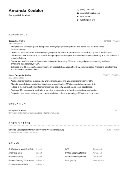
Replace generic activity descriptions with results tied to geospatial work. "Analyzed over 5,000 geospatial data points, identifying significant patterns and trends" is stronger than "Responsible for spatial analysis" because it shows scale and the purpose of the analysis. The sample resume also does this well with database accessibility improvements, project efficiency gains, and stakeholder presentations.
Quantify outcomes where the numbers reflect real geospatial performance. Useful measures include data volume, accuracy rates, turnaround time, database accessibility, map output count, field collection totals, or project efficiency. Examples like improving data accessibility by 40 percent or data accuracy by 25 percent work because they connect directly to how spatial analysis supports operations and decisions.
Tailor each role so the bullets reflect the target opening first. If the employer asks for GIS software, remote sensing, database maintenance, and communication with technical and non-technical stakeholders, make sure those appear naturally in your experience. You do not need every past task on the page. Keep the bullets that show you can analyze, maintain, collect, and explain geospatial information in a professional setting.
After this section, the reader should understand the scale of your analysis, the systems you worked in, and the results your work produced. That is what separates a resume full of GIS terms from one that clearly supports a Geospatial Analyst hire.
Education matters in geospatial hiring because it establishes your grounding in spatial analysis, GIS concepts, data interpretation, and often remote sensing or cartography. Keep this section concise, but make sure it clearly supports the technical baseline the role expects.
If the role asks for a bachelor's degree in Geography, Geospatial Science, GIS, or a related field, make that easy to spot. List the degree, field, school, and graduation year. In the example, "Bachelor's degree, Geospatial Science" aligns directly with the requirement and needs no extra explanation.
Use a straightforward format rather than turning education into a long narrative. For most Geospatial Analyst candidates, the essentials are enough unless you are early in your career or your coursework fills an experience gap. The reader is usually scanning here to confirm degree level and field relevance.
If your degree title is close to the employer's wording, use the version that best reflects both your credential and the posting. For example, Geography, Geospatial Science, GIS, or a related field may all point to the same hiring requirement. Consistent wording helps ATS matching and keeps your background legible to non-technical reviewers.
If you are newer to the field, include selected coursework, capstones, or research tied to spatial analysis, remote sensing, imagery interpretation, database design, or cartography. This is especially useful when academic work shows applied skills with ArcGIS, QGIS, field collection, or spatial modeling that your job history has not yet covered in depth.
Honors, thesis work, research assistant roles, or geospatial competitions can add value when they reinforce analytical credibility. Keep them if they help explain your path into the field or show stronger technical grounding. Leave them out if your professional experience already tells the story more clearly.
This section should confirm that your training supports the analytical and technical demands of the role. When the degree field is easy to find and clearly relevant, the reader can move on to the experience that proves how you apply it.
Certifications are not always mandatory in geospatial hiring, but the right ones can strengthen your profile, especially when they reflect GIS standards, ongoing professional development, or specialized spatial tools and methods.
List certificates that reinforce your geospatial credibility. A credential like GISP fits naturally because it supports professional standing in GIS and spatial analysis. Prioritize certifications tied to GIS practice, remote sensing, spatial databases, scripting, or related analytical workflows over general training badges.
You do not need a long list. A few strong certifications with clear relevance are more persuasive than a crowded section of loosely related courses. For a Geospatial Analyst, the best certificates usually point back to mapping systems, data analysis, imagery, field collection, or technical standards used in the work.
Include dates when the credential is current, recently earned, or requires renewal. That context helps the reader understand whether the certification reflects active practice. The example's GISP entry works well because the date range shows that the credential remains in force.
Geospatial work shifts with new data sources, collection methods, and platform capabilities. Recent learning in remote sensing, Python for GIS, cloud-based geospatial tools, or database management can strengthen a resume, especially if the target role leans on newer workflows or interdisciplinary collaboration.
A well-chosen certificate section should back up your technical profile, not distract from it. If the credentials you list clearly connect to geospatial analysis work, they add confidence without taking much space.
The best Geospatial Analyst skill sections look like a hiring checklist translated into real capability. They should show the platforms you use, the analytical strengths you rely on, and the supporting skills that help you move from raw spatial data to usable outputs.
Start with the skills named or implied in the role. Here that means GIS software, remote sensing, geospatial data analysis, problem-solving, communication, and likely database handling or field data collection. Build your list from the actual workflow of the job, not from a generic library of GIS terms.
Include a mix of technical and applied skills. ArcGIS, QGIS, GPS, remote sensing techniques, database management, and Python scripting for GIS are strong hard-skill examples. Pair them with analytical and communication skills because geospatial analysts are often expected to interpret findings and explain them in reports or presentations, not just generate spatial outputs.
Order the section around what the target employer is most likely to care about first. For this opening, GIS platforms and remote sensing belong near the top, followed by analysis, database, and communication strengths. The sample resume handles this well by foregrounding ArcGIS and QGIS, remote sensing, GPS, and database management instead of burying them among less relevant skills.
A focused skills section helps the reader understand your operating range quickly. When the list reflects real geospatial workflows, it supports both ATS alignment and a more credible reading of your experience.
Geospatial analysts often work across technical and non-technical audiences. Language ability matters less as a standalone feature than as a practical part of reporting, collaboration, and presenting findings clearly, especially when a posting specifies an English-speaking environment.
Check the posting for explicit language requirements before you decide what to include. Here, the ability to operate in an English-speaking work environment is clearly stated, so English should appear on the resume with an accurate proficiency level.
List English first when it is mandatory for the role. This keeps an important screening item visible and removes doubt about your ability to handle written reports, cross-functional discussions, and presentations of geospatial findings.
Additional languages can be useful, especially in organizations working across regions, field operations, community engagement, or international datasets. They are not a substitute for geospatial skill, but they can strengthen your profile when collaboration or geographic context extends beyond one language.
Be precise with ratings such as Native, Fluent, Advanced, or Intermediate. Overstating language ability can become obvious quickly in interviews or presentation settings, and communication is already a core part of many Geospatial Analyst roles.
If a second language supported field coordination, client communication, or interpretation of regional information sources, that can be worth mentioning elsewhere in the resume too. The main point is relevance. Include language capability when it supports the way geospatial work gets delivered.
This section should quickly confirm that you can communicate in the environment the role requires. Any additional language skill should feel like a useful extension of your work, not filler.
The summary is where you frame your experience before the reader reaches the detail. For a Geospatial Analyst, that means naming your level, your main technical ground, and the kind of results your analysis has supported.
Start from the role you want, not from a vague identity statement. Use "Geospatial Analyst" if that is your target, then connect it to your core strengths such as GIS platforms, spatial data analysis, remote sensing, database support, or stakeholder reporting. This keeps the summary specific from the first line.
Give the reader a quick sense of scale with a clear opener such as "Geospatial Analyst with 4+ years of experience." That immediately frames how your later claims should be read. The sample summary does this effectively and then follows with the main areas of practice.
Choose the strengths that best match the target job. For this posting, strong options include GIS software proficiency, geospatial data manipulation, remote sensing techniques, cross-functional collaboration, and presenting findings to technical and non-technical audiences. Add one or two outcomes if possible, such as improving data accuracy or project efficiency, to keep the summary grounded in results.
Aim for a short paragraph that can be read in seconds. Avoid generic lines about being passionate, dynamic, or results-driven unless they are backed by actual geospatial work. A concise summary built around tools, analysis scope, and measurable contribution gives the reader a sharper first impression than broad professional adjectives.
By the time someone finishes your summary, they should know your level, your technical focus, and the business value of your geospatial analysis. That gives the rest of the resume a clear frame.
A Geospatial Analyst resume works best when every section points back to how you handle spatial data, support decisions, and communicate findings. Use the job description to prioritize the right evidence, whether that is GIS platform depth, remote sensing work, database maintenance, field collection, or reporting to mixed audiences.
Wozber's free resume builder can help you turn that experience into a well-structured, ATS-friendly resume format, and its ATS resume scanner helps you check whether the language of your resume actually matches the role. The final result should make it easy to judge your readiness for real geospatial analysis work.